If you want to see newer pictures, be sure to follow my new page:
Nooks and Crannies II
I have moved! Check out my new site at Nooks and Crannies
Memory Full
Well, Im maxed out. For a while they were offering straight memory for purchase, however currently the only option is 100/year. I just don’t have it in me to pay that much for my amateur camera/phone pictures. Not sure what Im going to do. I could delete from the archive, but was hoping to keep a record of how the world looked back then… Hopefully things will change. I mean really, cloud data storage? Should be cheaper than air! Maybe Ill move to Instagram or facebook. Im gunna give it some time, but no new pics for a while…
Love Letter Springs
I had the fortune of driving to a job near Hayfork, CA this summer. The job went super quick and I ended up with a day to kill – so I set our to explore some backroads between Hayfork and Big Bar. You can take Barker Creek Road to eventually get to Coral Bottom Road and then over to Big Bar. There are also endless USFS roads that go off in all directions. I happened to notice a neat looking ridge that had a spot named Love Letter Springs on the map. With a name like that, I couldn’t resist checking it out.

So many roads I tell you…
In the lowlands, the forest transitions from oak woodlands to conifer forests. It is evident that there once was way more of this oak woodland, largely due to Douglas-fir encroachment. As fire suppression in northern California reaches its 100th year, we see the last of the oak stands being swallowed up by conifers.

As you leave the lowland valleys the road leads into the deep forests that make up the Shasta-Trinity National Forest. These forests are diverse, and many different forest types are found along these roads. Douglas-fir stands appear to be the most common.

In the higher elevations, true fir species, pine and incense cedar become more common. The composition of these forests are largely driven by fire disturbance. Indeed most of these ridge lines have been used as fire lines during firefighting efforts in the past several decades.

This became more evident as the road passes through more recently burned timber. Many view forest forest fires as devastating, however this is seldom the case. In wilderness areas, fire – while they may look destructive – create tremendous life. Dead trees lure large populations of insects and as result chum up the food chain in the form of food for birds and reptiles, while advancing decay in standing snags that will provide nesting structure for many birds and small mammals.


Fire also creates a mosaic of forest layers that increase diversity. Grass and herbaceous plants tend to thrive post fire and these reinvigorated regrowth is highly nutritious for grazing animals like deer and elk. I write this is the wake of a busy fire season Humboldt County and indeed the whole State. While many people get frustrated by “let it burn” policies in national forests, its important to understand the benefits of fire. It also should be known that fires have always been part of the climate in western forests. Millions of years of evolution have shaped the disturbance-response effects of forests, from the serotonous cones of pine trees that only open following fires, to the development of large cavities in trees that many species depend on.

Love Letter Springs
Tried as I might to find the backstory of this place, I found nothing. Most place names tend to be either practical names, like the names of homesteaders or ranches, or names that signify some hardship – like Hells Hole or Devils Elbow or Starvation Flat…This spot got a name that seems inspired by someones love. A rare thing, at least on a map. And sitting near this cold water spring, high on a mountain you can see how one would find inspiration. A magnificent view perhaps fueled the longing to write to a loved one in the mists of desolation.


Even if you prove to me that you have the blemishes you think you have, it cannot appall me any, because with them, you will still be better, and nobler, and lovelier than anyone I have known. I will help you to weed out your faults when they are revealed to me but don’t you be troubled about the matter, for you have a harder task before you, which is helping me to weed out mine. Let me pay my due homage to your worth; let me honor you above all others; let me love you with a love that knows no doubt, no question– for you are my world, my life, my pride, my all of earth that is worth the having. Let us hope and believe that we shall walk hand in hand down the lengthening highway of life, one in heart, one in impulse, and one in love, bearing each other’s burdens, sharing each other’s joys, soothing each other’s griefs. What we will lose of youth, we will make up in love, so that the account is squared, and to nobody’s disadvantage. I love you, my darling, and this my love will increase, step by step as tooth by tooth falls out, mile-stoning my way down to the great mystery and the Sweet Bye & Bye.
For I do love you… as the dew loves the flowers; as the birds love the sunshine; as the wavelets love the breeze, as mothers love their first-born; as memory loves old faces; as the yearning tides love the moon; as the angels love the pure in heart…
Take my kiss and my benediction, and try to be reconciled to the fact that I am
Yours forever,
S.L.C
[aka Mark Twain]

Spring Recap

Hard to find blogging time as of late, so I thought I catch up and post a few of my last good pictures from this spring.

Last time Lassic caught a dusting of snow. Sadly it is apparently an inferno now, as the Lassic fire continues to burn. I plan on taking a photographic adventure up there this winter to document the fire.


And a few more from the same day. This little bit of snow was just not enough to have any measurable impact on ground water recharge. Normally, where I took these pictures, snow drifts would be in spots like this until at least June – generally preventing access. This year all the snow was gone by early May – and it was a pathetic showing. What will El Nino bring? Warm rain? We need a snow pack bad, so hopefully we get good rains but more importantly snow.

Houdini the Owl

Meet the elusive Houdini. I have been monitoring this owl for about 5 years now. Normally we find the birds, offer them prey and if they are nesting will fly to their nest, or young, or mate… This is how you define a spotted owls territory and thus are able to protect it from nearby logging. Every so often a owl pair will not play along. Like this one, who has never shown me a nest. In fact they always disappear in the prime nesting weeks. The male here, is not shy however. As long as I bring gifts…

In The Clouds

Live Oak

Mosaic Forest

The Old Home

Taylor Ridge and Beyond

Oregon White Oak

These trees have a way of catching my eye. I love their style. If you are wondering why I have not been posting much, its largely due to my workload. Im also creeping up to my maximum storage limit on wordpress, so will have to consider purchasing some memory from the internet. Never thought Id ever write that sentence…
Fractured Earth

While exploring a rock outcrop, I found that it had a crack that more or less went through the whole formation. Caves are rare in our area, so I was curious if I could [safely] find one in this sandstone rock complex. While fractured rock is the name of the game in the Fransican sandstone make up of most of Humboldt County, its neat when you can explore a large, intact chunk of solid rock.


From the top of the rock I could see down in some places into a deep crevasse. This fracture went down as far as I could see, at least one hundred feet. I followed the crack to the edge of the cliff, and did my best to memorize a few trees that were growing at the base of the rock, in hopes I could find them on the other side. In this way I could try to find this fissure from the bottom and see if there were any caves.


From the bottom, I note that shadows create the illusion of potential caves, but closer inspection revels that this outcrop is solid. And massive, at least relative to other rocks near it. The cliffs here are 100-200 feet. I find the trees I remember, but dont see any openings. But there is a large talus slope, broken up rock the accumulates on the base of cliffs, that leads up to a small ‘valley’ in the rock face.


And…lo and behold there is a cave, of sorts. Right off the bat, this place is dicey. A cave has formed by large pieces of rock becoming wedged into the large crack. It looks precarious for sure, but its not moving. Well, unless there was an earthquake…. Still I work up the courage to go in…I didnt sweat all the way up here for nothing!

I work my way in about 50 feet before I start to have second thoughts. Infact the thought of an earthquake is really hard to shake from my mind. I know as a fact that this rock outcrop sits right on a local fault known as the Gordon Fault.


Then I get to this spot where the ‘floor’ just disappears into darkness. I realize I am standing on large rock fragments wedged into the crack, much like the ‘ceiling’ above me. As I look down, I cant see anything that resembles a bottom. I attempted to use my camera flash to capture this depth, but the perspective was hard to shoot – at least with my phone camera.

Well, no long lost treasure or hundreds of bats. But I was pretty satisfied with my adventure. For Humboldt County, this is a pretty unique rock formation. One for books for sure.


Old Growth Trip

When I have the opportunity, I love to explore old growth forests. These are plentiful in Six Rivers National Forest, as well as Shasta-Trinity and Mendocino National Forests. Here some pictures from a recent adventure. This forest is almost what would be called “California Mixed Conifer” but has some coastal nuances. Less pine and the presence of tanoak, alder and certain willow. These forests are also what we call “primary” forests, never been logged. Many thousands of acres of forest along South Fork Mountain transitioned from oak woodlands and savannah in the past several hundred years. Here is another example of transition – in an extreme sense – from oak to conifer forest.


Holm Owl

This guy. Ive been chasing him around for about five years, but this year I finally found him. He lives in a nice patch of old growth Douglas-fir forest on the Mad River.


Mountain View

Van Duzen Rocks!

Middle Mad River

Lasers in the Jungle

These are the days of lasers in the jungle, lasers in the jungle somewhere…
Cow Creek

Spring Flower

Old and New

Taken from the old 299, North Fork Mad River.
Under the Bridge

The Juniper Tree

Once again I have had the fortune to enter a strange, unique wilderness located in the back country of Humboldt County. This place is known as the Eaton Roughs, which is a sandstone block that has surfaced in the past few million years via faulting. The Roughs now hold a small island of unique vegetation, for the coast range, with many plants that you would expect to see in the Klamath Mountains or the Yolla Bollys.


One species in particular was on my mind for the day; Juniperus sp.. Last time I was in this area I came across what I was fairly confident was a juniper, however I was unable to key it properly. This time I was set to verify what kind of tree this is, or at the very least collect enough data to have people smarter than me help identify it.


There are only a few species that this tree can be. Juniperus grandis (Sierra), Juniperus occidentalis (Western) or Juniperus communis (Common). Initially I thought that these could potentially be sierra juniper – due to their form. While pretty limited, my experience with western and common juniper were that they often where more shrub-like. However after more research and examination, I am now pretty confident that these are indeed Juniperus occidentalis, or western juniper.

According to Michael Kauffmann in Conifer Country, the oldest known western junipers are 1,000-1,500 years old. I found several trees that looked like the one above, gnarly and obviously quite old. Could they be over 1,000 years old? Another interesting fact is how apparently their range has increased in the past 50 years. While climate change is one potential explanation, fire exclusion seems to be the most likely reason. This has certainly been true in this region as well, and this may be why I found abundant regeneration throughout the Roughs.


I would appreciate any comments to confirm or refute if this is western juniper. I did collect some leaves, bark and berries – if required.


More old specimens

Juniper snag


Coming Soon…

Pictures. If I can find time to blog about them…You can try to guess from this picture what the next tree feature will be.
Return to the Hidden Canyon

I was able to crawl up into my secret canyon again. This place in one of the coolest places I stumbled on, and despite its impressive scale, it is very well hidden. The canyon is about 400-500 feet long and has sheer cliff walls that are close to 80 feet. Too bad I only have a phone to take pictures with. This spot certainly deserves better, and as with last time, I am a little disappointed in the pictures. The light was not the best for me and well lets face it, Im just a forester with a camera phone. LOL Someday I will get a real camera, or take a real photographer here.


Conifer Country: Book Review
Today I offer my first book review; Conifer Country; A natural history and hiking guide to 35 conifers of the Klamath Mountain region, by Micheal Kauffmann. It is put out by our very own Backcountry Press who has put out some real neat books in them past few years.

The book is essentially a tree guide with companion hikes for all the species that occur in the region. But unlike most tree guides, which are generally about as exciting as dictionaries, Conifer Country describes each tree in a naturalist style of writing. There is just enough ‘technical’ information to properly identify the trees but the best part is the description of the trees ecology and how they fit into the landscape. This is done very well and makes the guide section fun to read, assuming you are interested in trees.
The author is certainly inspired by John Muir and like Muir, he really captures the essence of the Klamath that one only can obtain by spending significant time there. This is evident in the writing and I get the sense that the author is truly in love with these mountains and trees.
Confer Country is a great book for hikers and naturalists, beginners or veterans alike. Even if you are experienced in the area, you may just find several bits of interesting information that you did not know about the Klamath. I sure did! As a forester, I read technical writing all the time and while I of course enjoy the scientific aspect of things, I have always found great peace in naturalist writing.
If you are a follower of my blog and/or live in this area, i guarantee you will not be disappointed with this book. I have heard from one or two people that the hiking guide has pointed out a few peoples ‘secret’ spots, but I have always believed that when it comes to hiking back country, anyone who is willing to go to these remote places is probably someone I wont mind running into.
Be sure to check out Conifer Country online for Micheal Kauffmann’s blog. He also posts digital versions of the maps in the book that you can download after you buy the book – which is a pretty awesome idea.
I will also plug my favorite book store: Eureka Books. This bookstore has a whole section devoted to local books, and often you can find signed copied. Go there and get Conifer Country today!

Fox Hole
I noticed this brush cave and decided to take a closer look. Its a willow of some sort. You can see how this would be an excellent hideout when it has leaves,and I probably would not have noticed this outside of the winter. I was actually pretty surprised when I noticed actual bones inside…
Baby Bear

Sunrise over Redwood Creek

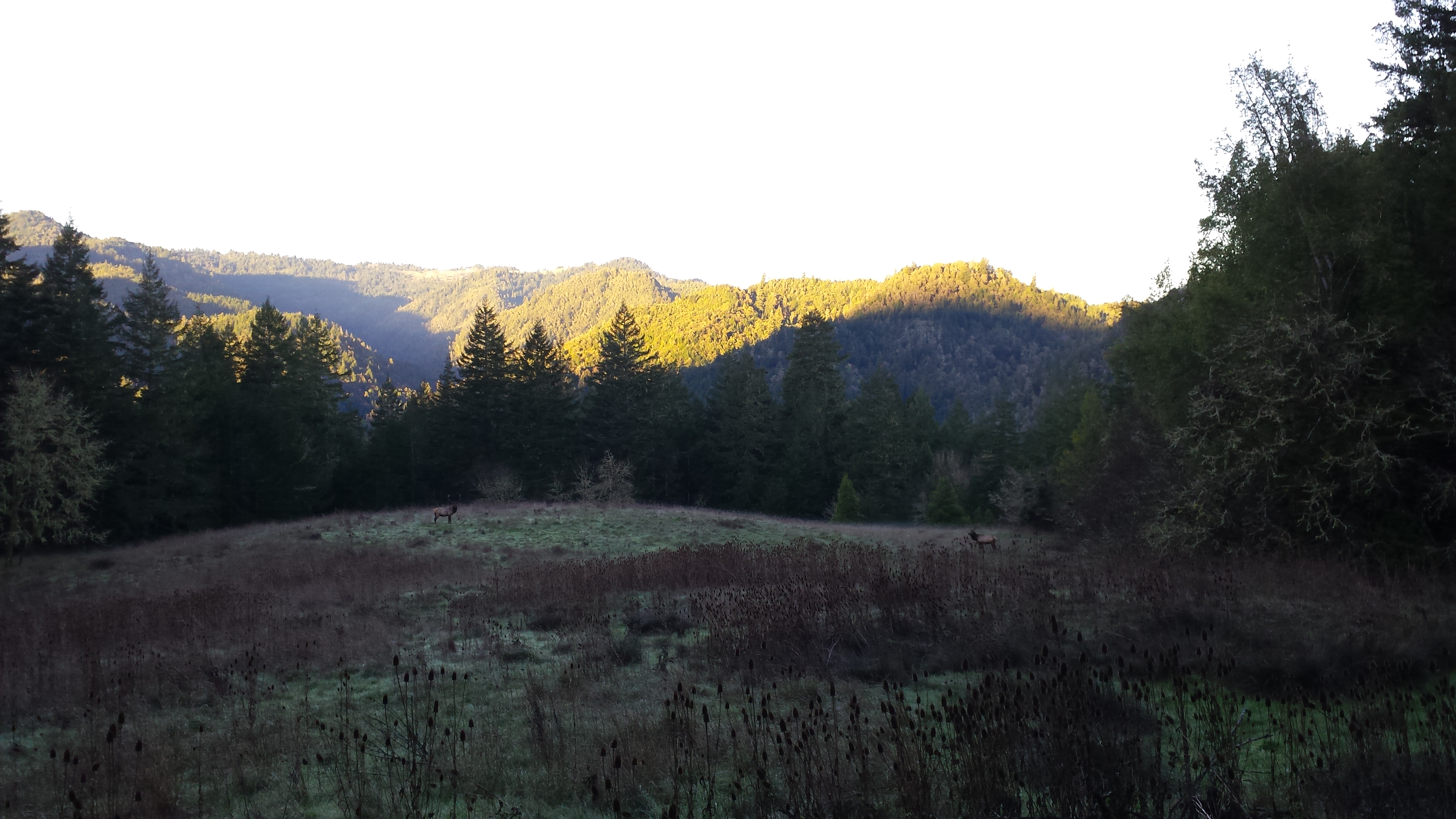
Elk Herd

This heard is a fairly common sight in Butler Valley.
Dusk over Redwood Creek
Sunrise Standoff!
Who is the king of the harem?
Post Harvest

A Douglas-fir forest that was harvested this summer near Orleans, CA.
Mandell Fire Plantation

I could not dig up much on the history of the Mandell Fire. It appears an extensive area near Hyampom burned, and the plantation is obvious when you drive through the forest near the town. The trees look good and are starting to reach heights of 30-40 feet. Now it looks like they should be thinned…


Hyampom Vinyard

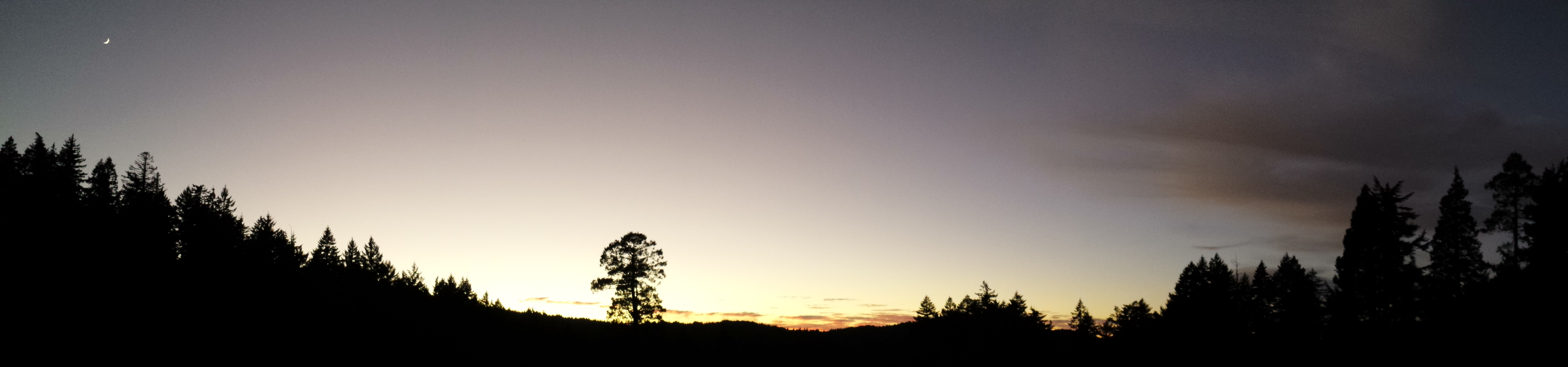
Mad River Sunset (J.J. Abrams Edition)

Mad River Sunset

Hot Fire

Unlike the previous pictures, this fire will leave very little behind. This was landing slash from logging in the Mad River.
Winter Burning

Here are some pictures treating slash piles following the summers fuel reduction projects. Unfortunately, it was too wet to effectively burn and we found the piles to be not covered correctly. So, hopefully we will get a second chance this winter for things to dry out enough to burn.

Most the piles would light, but consumption was poor.

Looks like a dragon nest!


Mature Forest

Mature Douglas-fir/tanoak forests located above Willow Creek, CA.
Willow Creek Radio Tower

I came across this place exploring off of Waterman Ridge above Willow Creek. If you ever marvel at your 3G reception in Willow Creek, you can thank this tower… It also apparently is a outpost for the fire department.
OK, so I got this wrong. What I meant to say was: “Ever wonder how emergency services transmit information in rural areas? Well, here is one of their remote antennas…”. Or something like that.

Bones


Old Cans


“Badger”

2014: Year in Pictures
A New Years tradition continues here at Nook and Crannies! This is my third year and I have added The 2014 Gallery. Once again, picking a favorite image is very hard, so this year I decided to pick out a few:
 The Grandfather Tree. This remains the largest, most interesting Douglas-fir tree I have ever encountered in Humboldt County.
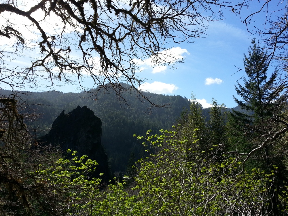 Mad River Rocks! This is one of the coolest rock formations I have found yet. I still hope to return to this location with better light and get some better pictures. However, I can say that I was able to return and confirm the presence of a peregrine falcon nesting on the rock.
 Baby Owls! Speaking of wildlife, this was one of my luckiest experiences this year, at least being able to get such good pictures of spotted owl monitoring.
What will 2015 hold? I hope to keep it going with pictures of our wonderful area. I also hope to actually find the time to explore more public places, such as the Klamath and Siskiyou wilderness areas. Who knows, maybe Ill even get an actual camera which would be a serious upgrade from my current camera phone. Happy New Year!
Black Lassic: Epic

Red Lassic: Panorama

The Lassics

One of the great places to visit of our area, Black Lassic. The great thing about this peak (5,900′), is that it is very easy to get right up on top. A road essentially crosses a broad saddle where Black Lassic connects with Red Lassic and Signal Peak. There is a turn off where you can park then walk a relatively gentle trail and be on top in 15-20 minutes. If there is snow, you might not be able to get as close so be prepared to hike for a few hours depending on how close you can get. The mountain is always in plain view so its not hard to know where to go, just make sure you get to the uphill side of Lassic before you try to get to the top. All the other sides of the mountain get extremely steep and most of it is fractured and unstable.


The Lassics are considered a unique geologic area where different pieces of ancient history collide. This grey and red soil is called ‘serpentine’ and is highly acidic, and even has naturally occurring asbestos within in it. While allot of this land can be barren, stands of incense cedar and pines can grow on serpentine. Where more developed soils occur, stands true fir stands develop.

I decided to scramble up to Red Lassic first. While this is not a hard hike, there is no trail so don’t try to take small kids or bad legs up here.

At first glance it looks like a simple enough walk, but you must cross these talus slopes and that can be hard on your knees. My knees seem to feel it more and more each year, but I have always enjoyed scrambling over this kind of terrain.


Eventually you get to relatively stable rock and can take in some fantastic views.

The highest point in this picture is called Signal Peak. I think there used to be a fire lookout here. When you visit this place, you can easily get to the top of all three of the peaks, Black Lassic, Red Lassic, and Signal Peak in a single day.

A nice view of Mad River Rock. That is on my radar for my next adventure. I have always wanted to explore it! Someday Ill find the time.

And of course a great view of Black Lassic from the top of Red.

Looking back at Red Lassic, it does not look that impressive, although shooting a picture into the sun never really works…

Making my way up Black Lassic, you can really see the black color of the rocks and soil, which is indeed in contrast to the red hue of Red Lassic.

And finally, the truly epic view. Mad River Rock again. Its the Van Duzen River between us and the Rock. The next ridge you see is ‘South Fork Mountain’ which drains the Mad River. I do not know what to call the next ridge line, however I know that the east side of South Fork drains into the South Fork Trinity River. I have some panoramas Ill be posting next taken from these peaks.
All the Rain Brings

